Nature-based solutions: Rivers & lakes
Rakaia River & Lake Coleridge – Image: Google Earth June 2021
 Rivers and lakes
 “Hydrologists have recognized for some time that climate change has undermined stationarity* in water management—indeed, they have declared that stationarity is dead. But economists have by and large not recognized that this applies to climate effects. They approach climate damages as minor perturbations around an underlying path of economic growth, and take little account of the fundamental destruction that we might be facing because it is so outside humanity’s experience… In effect, economists have assigned them a value of zero, when the risks are decidedly not.” – Profs. Naomi Oreskes & Nicholas Stern
Left: Aerial photo c. 1944: Canterbury Maps historical image galley
Right: Aerial image Google Earth 2018
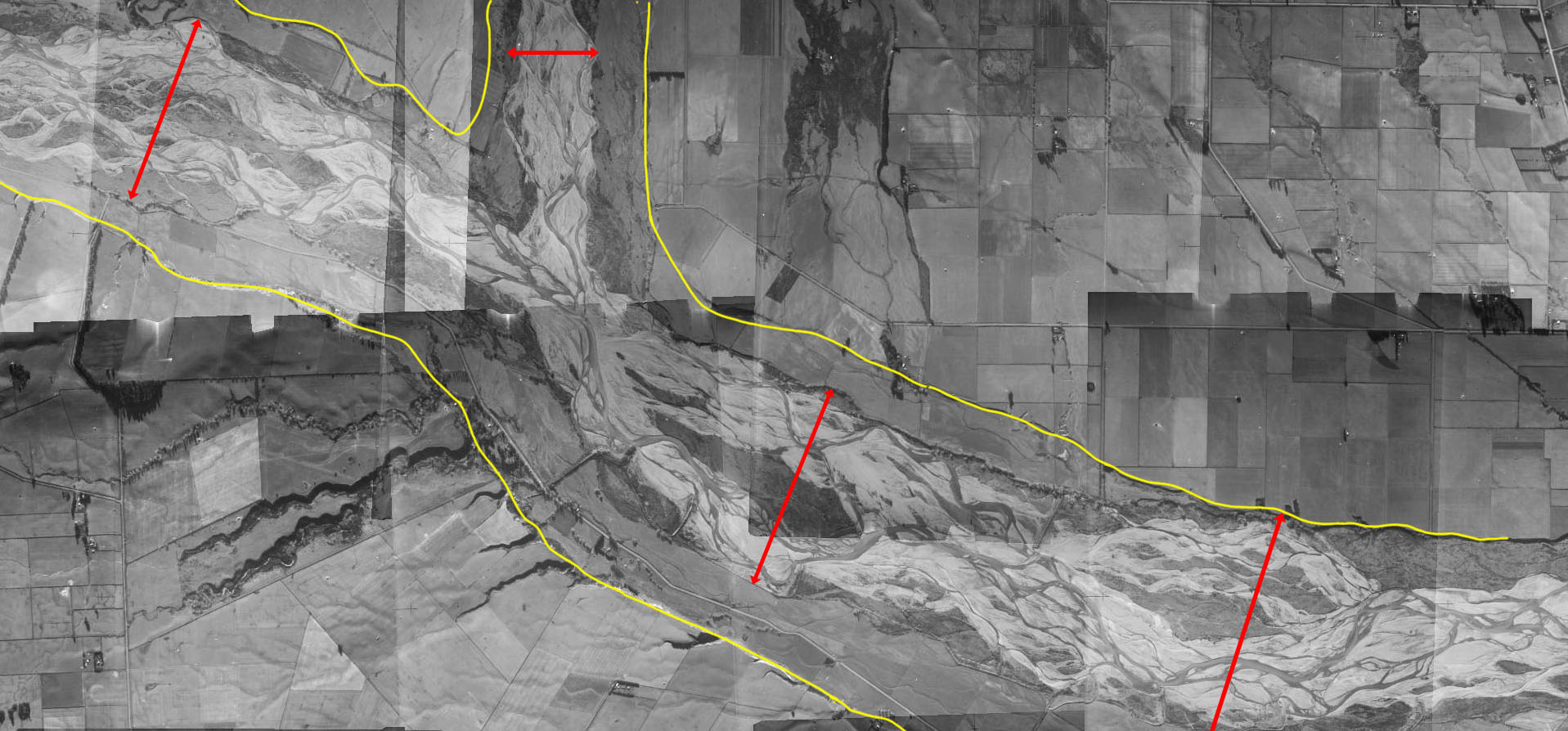
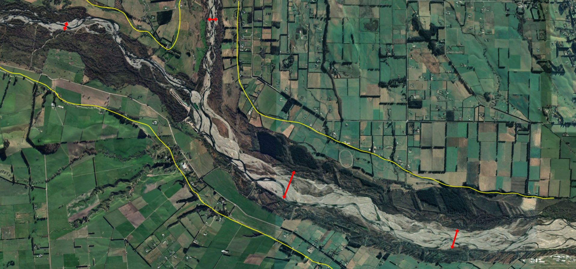
Fig. 1: The Okuku River (top centre left) merging with the Ashley River Rakuri, which then flows downstream to the town of Rangiora. Red arrows signify the width of the braided river braidplain (scroll down). Inside the yellow line is the approximate extent of the braidplain based on the geomorphology, i.e., indentations in the land showing where the braided channels were active prior to European settlement. Back then, the braidplains were largely free of vegetation other than low-lying native herbs and cushion plants, with smaller native shrubs interspersed with wetland vegetation around springs.
The scars of old channel are evidence that these rivers periodically flowed well outside the yellow lines (Fig. 5 is a good representation of this on a small scale.) Reducing the width of the braidplain so that just a few channels are allowed to flow in a confined space has already destroyed most of these ecosystems.
Climate change is leading to more droughts, exacerbating existing ecological problems. It’s also leading to higher bursts of rainfall that exceed their artificially restricted carrying capacity rivers, leading to extreme flooding. We are now facing a vicious cycle, with property owners blaming councils for failing to protect them and demanding greater protection by further confining the rivers. Digging deeper channels by removing shingle and/or building higher stopbanks does not dampen the energy of floodwaters, which are set to increase in frequency and intensity as the climate continues to warm.
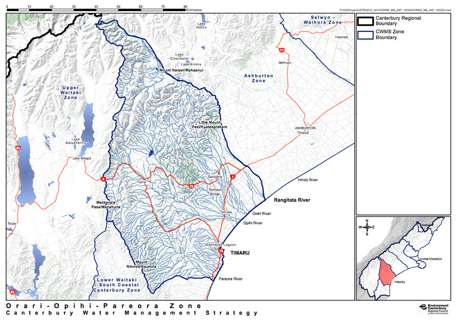
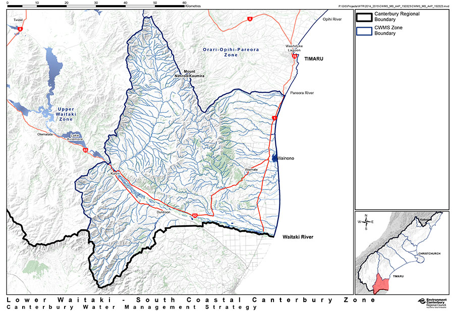
Environment Canterbury manages 59 river and drainage rating districts (i.e. areas where ratepayers contribute to the cost of flood protection). This map shows each rating district around rivers.
Areas outside these zones are not protected from floods.
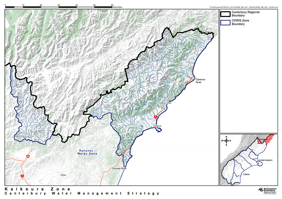
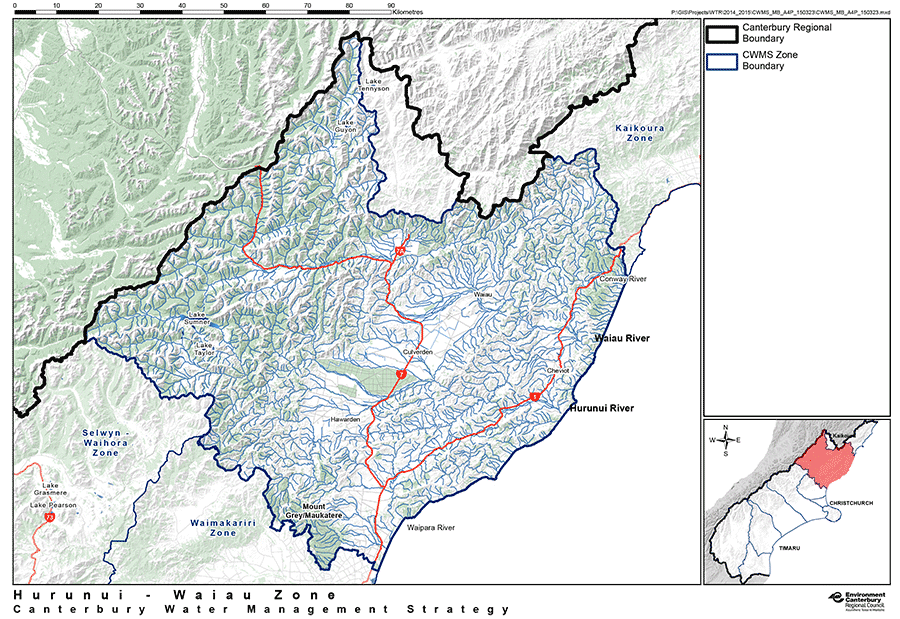
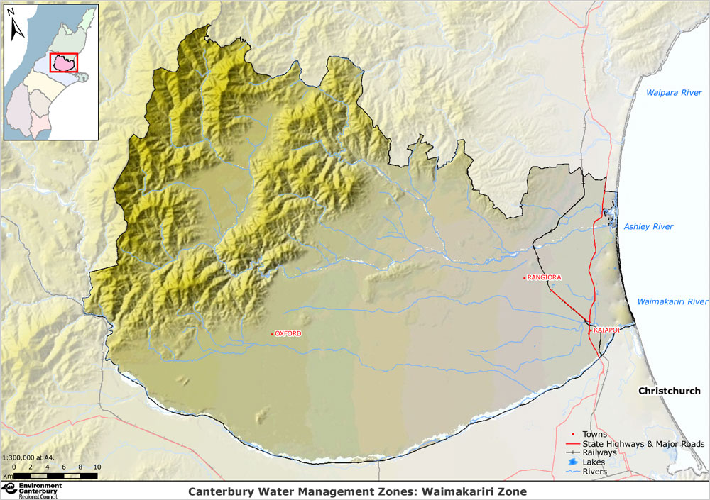
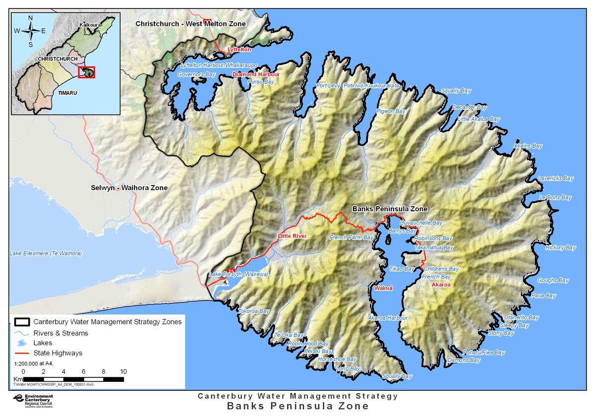
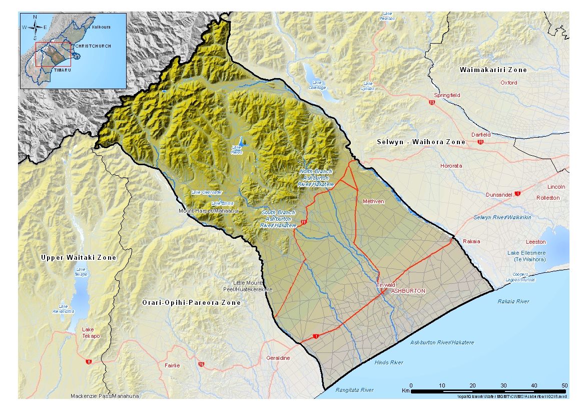
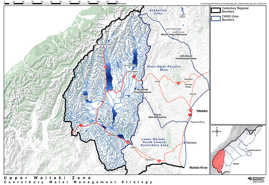
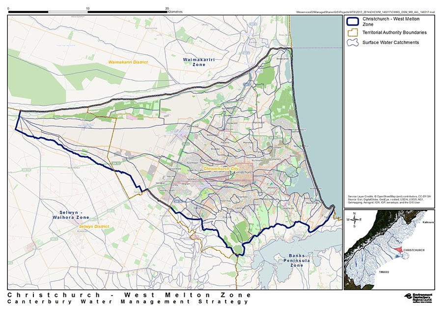
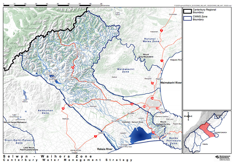
Under the Canterbury Water Management Strategy, the catchment of each waterway—their wetlands, groundwater, springs, lakes and rivers that flow down to estuaries—is considered together. Managing catchments in this integrated way means problems can be considered based on each catchment’s unique attributes. These maps will help you identify which catchment zone you are in.
Note that while there is overlap, these zone are not the same as river-ratings districts.
The problems
“The current wording of the Resource Management Act (RMA) allows this, as its definition of river bed assumes a static river channel. This is clearly inappropriate for braided rivers, which have multiple shifting channels.” – Brierley et al (2021)
Squabbles over water have been happening for thousands of years. The word ‘river’ comes from the Latin noun rivalis: rivals who use the same stream as a source of water. This saga continues in Canterbury, where an outdated approach to managing freshwater is being exacerbated by climate change. Here, rivers are seen as water sources to be mined for hydroelectricity and irrigation, flood risks to be defended against, braidplains to be converted to agriculture and forestry (Fig. 1), and drains to carry pollution to the coast. Economics drivers have turned our rivers into some of the most polluted rivers in the world (Video 1), where any drop that reaches the ocean is considered wasted:
“If things are going to get hotter, then we need to store water. It gives options and allows us to survive and thrive. New Zealand has been backward over water storage because we waste so much of it, it just flows out to sea.” – Conor English, Federated Farmers CEO 2008-2014; Agribusiness CEO 2014-
Along with many other problems, this prevents braided rivers from delivering sediment to the coast to keep pace with rising sea levels:
“The conventional wisdom is that you harvest flood water in the winter and store it until it’s needed (for agriculture) in the summer. However, floods are required to carry gravels to the coastal zone and if there’s not enough gravel, the waves get hungry and start eroding the land.” – Dr Scott Lanard, NIWA
The solutions
“Rivers and their floodplains have the potential to act as shock absorbers to climate change, and are powerful agents for keeping wildlife and communities healthy and resilient. The most effective climate action plans will account for this and incorporate rivers into their plans for a climate-resilient future.” – Michele Thieme, freshwater scientist, World Wildlife Fund
“The Commission recommends that the Government creates a climate-resilience agency…. the new entity should also assist regional councils and communities consider the best way to lessen future risk of flooding from rivers. This would include, where appropriate, the potential for using the best-practice model of giving rivers room and developing multiple innovative uses of the wider river corridors.” – New Zealand Productivity Commission 2019 draft report
Globally, as well as here in Aotearoa, there is a growing recognition that rivers of all types must be ‘given room to move’, that is, allowed to reclaim floodplains and braidplains so that they can act as shock-absorbers to mitigate the rapidly increasing risks of climate-driven mega-floods, and to recharge wetlands, which act as nature’s kidneys.
NIWA are now undertaking research to increasing flood resilience across Aotearoa.
Choices will need to be made: what to save and what to sacrifice.
Cantabrians are currently exposed to the greatest flood risk in all of Aotearoa (Fig. 2). Most of our cities and towns are built on braidplains and coastal wetlands, damaging or destroyed the ecosystems we need to help protect us in a warming world. While the pace of urban and rural river restoration programmes is accelerating, big choices still need to be made. To protect the relatively small spacial footprint of towns and cities and critical infrastructure (road, bridges, power supply, water supplies etc.) braided rivers need to be restored so that they can provide one of their key ecosystem services: dampening the effects of flooding by sacrificing less populated lands. Similarly questions must also be asked of all the other essential ecosystem services provide by biodiversity.
“River managers….cannot look to tools of old: conventional management techniques that aim to restore ecosystems to their original state. Ongoing human development and climate change mean that this is no longer possible. And models based on past correlations do a poor job of predicting how species might respond to unprecedented changes in future. A different approach is called for.” – Tonkin et al. (2019)
Planning and implementing a managed retreat from the edges of rivers, and restoring braidplains and coastal wetlands are critical preventative measure against such losses will be costly, but far less so than doing nothing, especially given the unavoidable impacts that rising sea levels will have on our coastal settlements beside these rivers, and the increasing frequency of devastating floods.
Choosing to do nothing takes away our ability to protect what’s really important to us.
Climate change
Glaciers: The changing climate is causing our frozen rivers—our glaciers—to rapidly shink. Lakes levels are no longer reliable, threatening hydro-electricity generation as well as water supplies for people and stock.
Droughts and floods: As Canterbury’s climate grows ever warmer, smaller rivers and springs are likely to dry up more often. Some, permanently. Perversely, rivers are also likely to flood more often with potentially more catastrophic avulsions as levees and stock banks built to hold back past floods fail to meet the challenges of increasing rainfall (Fig. 5) from atmospheric rivers (see Video 3).
“New Zealand has a potential FLHA [flood hazard area] land area of over 20,000km2, occupied by a usually-resident population of approximately 675,000. The FLHA has over 411,000 buildings with a NZD$135 billion replacement value (2016 replacement values). FLHA infrastructure network components include more than 19,000 km of roads, over 1,500km of railway, 20 airports, 3,397 km of electricity transmission lines and more than 21,000 km of three-waters pipelines.” – NIWA
Lakes: absorb CO2 from the atmosphere in the same way as oceans, becoming increasingly acidic. However, lakes also absorb CO2 from decomposing organic and inorganic matter, including pollutant runoff from agriculture. As they are becoming warmer, they can carry less dissolved oxygen. Together, this is leading to more toxic algae blooms (Fig. 3).
Dams: When a river is dammed, the blocked water that builds up behind it creates an unnatural, stagnant lake that eventually kills most of the original ecosystem that once existed there. Everything—plants, forests, the insects, microorganisms and fungi in the soils crucial for sequestering carbon—are all drowned. Bacteria and methanogens in the lake decompose the dead, emitting CO2 and methane. This bubbles to the surface adding more greenhouse gases into the atmosphere. Damming lakes for hydroelectricity is not as ‘green’ as you might think.
Key actions
Protect what remains of natural river and lake ecosystems. Refrain from building any more dams and irrigation systems. Under the RMA, braidplains are not recognised as integral components of braided rivers but agriculture continues to expand across them (Fig. 1). A change in the RMA is needed to protect them.
Remove introduced weeds and immediately stop planting more; this includes willows that have infested waterways. This would enable water flows to behave more naturally and have major benefits for wildlife.
Re-instate native plants along waterways to would enhance both aquatic and terrestrial ecosystems and help filter out pollutants, especially where waterways include wetlands, which act as the lungs and kidneys of ecosystems. In places where stopbanks have been put in place to protect towns, cities, and critical infrastructure, planting with natives links aquatic and terrestrial ecosystems.
Stop agricultural pollutants from entering waterways to prevent high nitrogen and phosphate loads downstream, including lowland lakes such as Tai Waihora Lake Ellesmere and coastal wetlands, estuaries, and oceanic ecosystems. This will help restore water quality, replenish mahinga kai, and reduce greenhouse gas emissions from the land, waterways, and ocean (particularly blue carbon).
Release strangled rivers to reduce the financial impact of floods and restore ecosystem services. This will require land currently used for agriculture on braidplains to be retired.
Enforce compliance. The ‘Essential Freshwater Package‘ aims to prevent further degradation and improve water quality. It requires regional councils to implement policies (that Fonterra and some elected officials object to, even before the additional requirement to consider climate change.Video 1 and Mike Joy’s article):c
“I remain concerned about council capacity to implement these new policies, especially given most councils were struggling to implement the freshwater reform package passed by the previous National government.” – Dr Nicholas Kirk, Environmental Social Researcher, Manaaki Whenua – Landcare Research

Lakes

Braided rivers are different to ‘normal’ rivers
Braided rivers originate in Southern Alps Kä Tiritiri o te Moana and most flow all the way to the ocean. Most of the time, only a few channels or ‘braids’ of water flow between temporary shingle bars and islands (see the Rakaia River image at the top of this page). Following storms and snowmelt, water levels rise rapidly and some or all of the braids join together to become a single wide channel across the area known as the braidplain. When water levels drop, new channels and islands will appear in different places across the braidplain (Video 2).
The origin of these globally rare ecosystems began around 40 million years ago, when tectonic forces pushed Kä Tiritiri o te Moana out of the sea. Over millions of years, a staggering 20 kilometres of the Earth’s crust was uplifted. Heavy rain and snowfall (as much as 12 metres annually) and glaciers eroded the mountains, creating huge volumes of moraine gravels and sediment. Fast-flowing rivers carried the sediment down through valleys and deposited it into the shallow seafloor surrounding the mountains. So much sediment accumulated that it eventually built up to become land. The rivers flowed over this new lands, spreading out into their distinctive braids and creating deltas, depositing some gravels here, and eroding them elsewhere until they built so much and that joined into a giant ‘megafan’ that we now call the Canterbury Plains.
Figure 4 is a good example of what that would have looked like, albeit at a much smaller scale.
Flowing from the mountains to the sea, braided rivers supported some of the most biologically rich and diverse landscapes on Earth. The sudden rise of water levels in them is not only normal, it’s an essential and defining feature that gives braided rivers their name.
Without these abrupt changes in river flows, these incredibly diverse ecosystems and the services they provide—clean water, plentiful kai, and bringing sediment to the coast to keep pace with rising sea levels—would vanish along with the rich biodiversity they support.
When Europeans settled Aoteaora, they viewed these high water events as dangerous floods rather than life-giving services. They systematically forced the braids into narrow spaces by building stopbanks and levees to contain them. Willows were planted to suck up the water and to stop the floods from eroding what was rapidly being converted into ecologically barren agricultural lands. Huge volumes of water was a siphoned off to irrigate these green deserts.
Today, these past actions are still ongoing. Willows and invasive weeds like lupins and broom are adding to the destruction of these rivers, by turning temporary shingle islands into permanent ones, forcing the braids to cut deep channels that accelerate during high water flows instead of drawing off energy as they once did. Every aspect of what it once was to be a braided river ecosystem is being taken away.
But heavy bursts of rainfall over Kä Tiritiri o te Moana will intensify as the climate changes (Fig. 5). The rivers will find chinks and force their way through man-made barricades, dragging fences, uprooted trees and other debris along with them, smashing them into bridges and buildings as they reach for the sea.
It’s time to give these rivers room to move. If we don’t, as the climate warms, the cost of them reclaiming their place as braided rivers will be staggering (Fig. 2).

Projected changes to rainfall


More information
Canterbury Water Management Strategy
Find out what catchment you’re in and which zone committee you can speak to about helping to protect and restore wetlands and waterways in your area, by clicking on the catchment maps below: