Impacts: Rising sea levels – Canterbury case studies
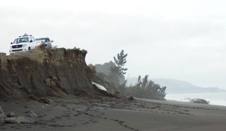
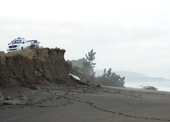
Conway Flat, North Canterbury image: Sonny Whitelaw
Case study: braided river mouths
The Canterbury Plains have been build over time by deposition of sediments carried from the Southern Alps by braided rivers. While tens of metres thick in places, this relatively soft alluvium is easily eroded. Rising sea levels will accelerate existing coastal erosion and speed up the retreat of the coastline.
Rivers that originate in the mountains are much larger than those that originate in the foothills. As the climate changes, these larger rivers are projected to flood more often as rainfall increases in their catchment areas. The volume of water in rivers that originate in the lowlands is projected to decline as rainfall here declines and the risk of drought increases.
In spite of—or in fact because of—their highly variable flow regimes, one of the unique attributes of all braided rivers, no matter where they originate, is the complex formation of channels and hāpua where they meet the sea.
By definition, this dynamic configuration naturally changes with floods and storm waves, so that from year-to-year, the hāpua and the gravel bars that contain them may migrate north or south of the main river channel.
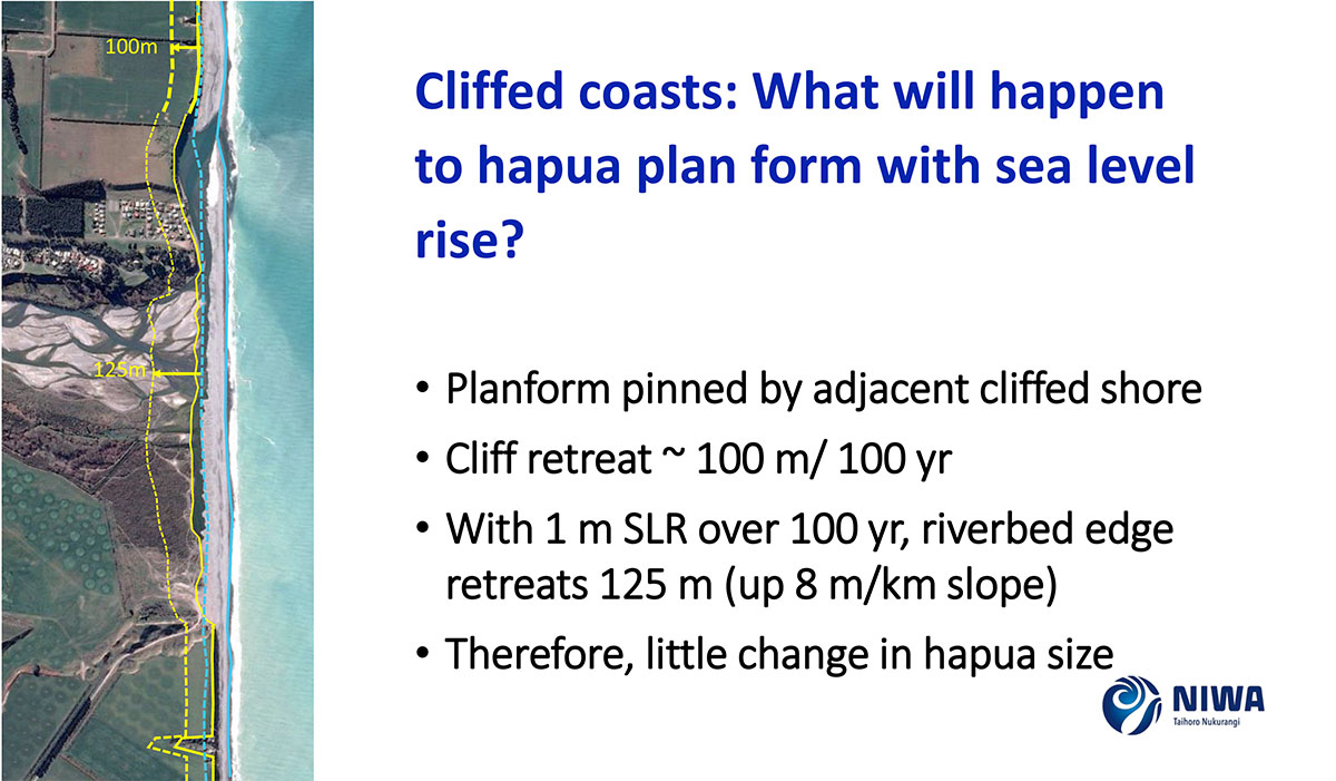
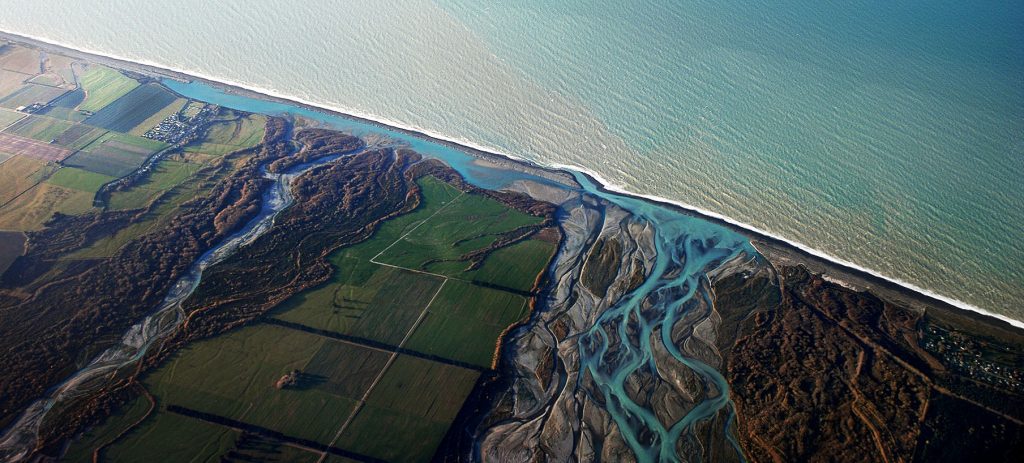
While rising sea levels are exacerbating the erosion of the coastline, even if rivers originating in the foothills flood less often, or even dry up during droughts, some of this eroded material from cliffs (made from alluvial deposits) either side, should continue to provide an ongoing supply of sand and gravels to river mouths. Here, hāpua, with their rich biodiversity and sources of mahinga kai, will most likely migrate inland while maintaining their general (albeit highly dynamic) configuration (Fig. 2: eg Hakatere Ashburton River mouth at Ashton beach).
Other hāpua that form at the mouth of low lying rivers such as the Rakaia River, may become saltwater estuaries instead. See here for other examples and a fuller explanation.
Case study: Pegasus Bay coastline
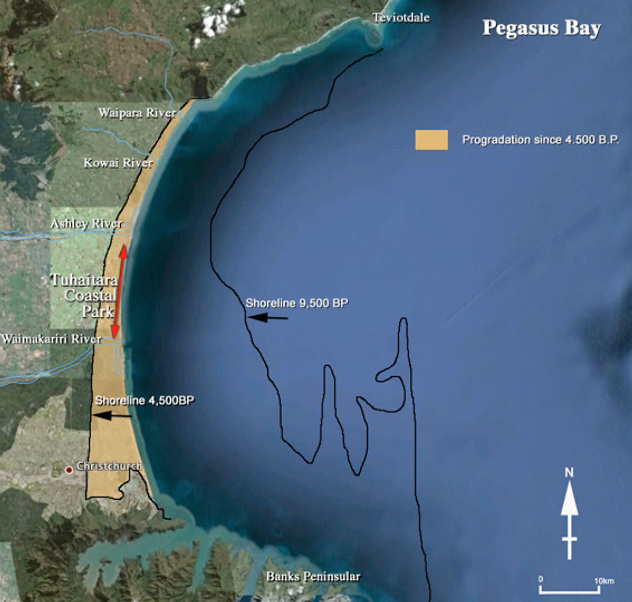
The Waimakariri River is one of several Alpine-fed braided rivers that formed the Canterbury Plains by depositing material eroded from the Southern Alps. Today, the river enters the ocean to the north of the low-lying city of Ōtautahi Christchurch, just south of the equally low lying town of Kaiapoi. However this was not always the case. Over the past several thousand years the river has migrated across a wide area. Sometimes it reached the sea south of the Banks Peninsula through Te Waihora Lake Ellesmere, what is today a very large hāpua. At other times the river has reached the sea where it is today, albeit through a much wider outlet. When it flooded, the river spread sand and shingle across the coastal delta. This prograded (built the beach outwards) the shoreline over the past 4,500 years when eustatic (global) sea levels were relatively stable (Fig. 3).
To protect Ōtautahi Christchurch and Kaiapoi from floods—or from a path being torn through multiple towns and farms if the Waimakariri tries to once again migrate south of the Peninsula—the river has been confined by engineering so that it now flows through a vastly restricted corridor. By the time it reaches the ocean it’s confined to just one channel with an outlet to Brooklands lagoon. Confined, sand and gravel that once build up the coastline through natural flooding, is now carried out into the ocean. Some falls into water that’s too deep for beach-building waves to carry ashore. Some is still carried onshore by currents and waves that distribute it along the bay. But the dunes and dune plants that once held this sediment in place have largely been removed or replaced with buildings, farmlands, and radiata pine plantations.
After 4,500 years of extending seaward, the coast stopped growing in the 1990s. Since then, the rate of sea level rise has more than doubled.
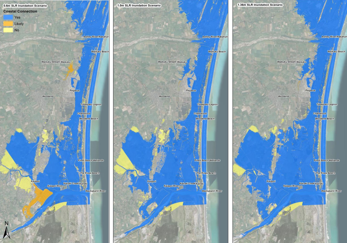
As sea level rise accelerates, the effect along different parts of Pegasus Bay will differ for reasons explained here (see also Fig. 4).
See how biodiversity is being restored along the coastline at Tuhaitara Coastal Park between the Rakahuri Ashley River and Waimakariri River, to help mitigate and adapt to the impacts of climate change.
Cast study: Ōtautahi Christchurch
“In this paradigm [Christchurch earthquakes], risk reduction decisions are highlighted as key influences on outcomes. As applied to natural environments, decisions are required to prevent the reaching of tipping points that result in loss of natural features and resources. This study illustrates the potential for rapid sea-level changes to exceed such tipping points with deleterious effects that result largely from anthropogenic influences.” – Orchard et al (2020)
The effects of rising sea levels on Ōtautahi Christchurch are complicated by the city’s highly varied coastal topography. The main city and suburbs sit on a low lying delta and vulnerable ‘soft’ coastline at the southern end of Pegasus Bay, more than half the length of which is wetlands, estuaries, and a low sand spit. The greatest length of the coastline, the Banks Peninsula, is made up of basalt cliffs, and deep narrow bays. The southernmost section is Kaitorete, a 25km long sand and gravel spit fronting the hāpua Te Waihora Lake Ellesmere, that was once the mouth of the Waimakariri River.
Sections of this coastline changed during the 2011-2012 Canterbury earthquake sequence. Parts were pushed up; others down. These physical changes and the human response is a case study for how we go about addressing rising sea levels in the future. The impetus to reduce the risks associated with rising sea levels can itself exacerbate these risks by destroying natural habitats that act as natural defences:
- The most recent report on the predicted impacts of rising sea levels to Ōtautahi Christchurch is from the summary and full technical reports from Tonkin & Taylor: Coastal Hazard Assessment for Christchurch and Banks Peninsula (2021).
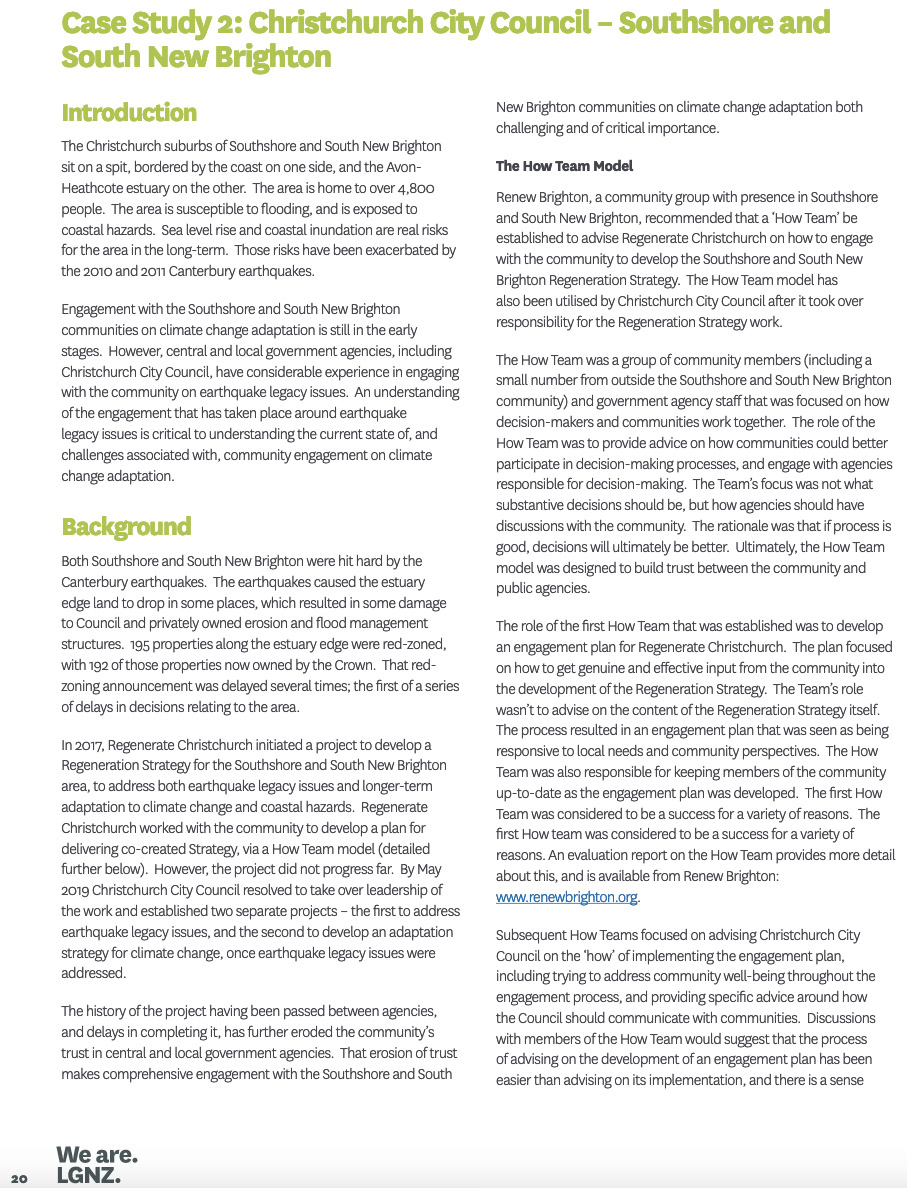
- The Local Government Community engagement on climate change adaptation (2020) report includes a case study on Southshore and South New Brighton (Fig. 5).
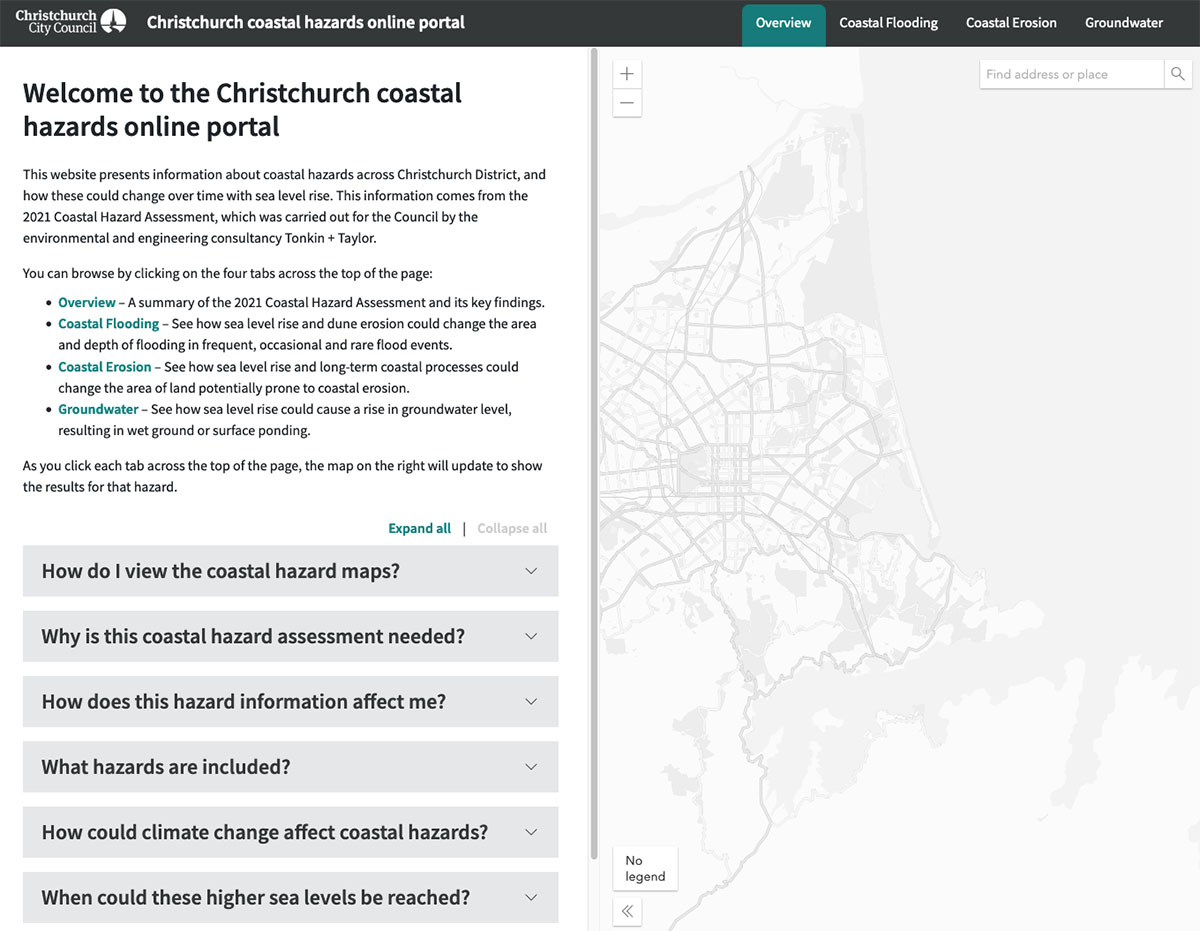
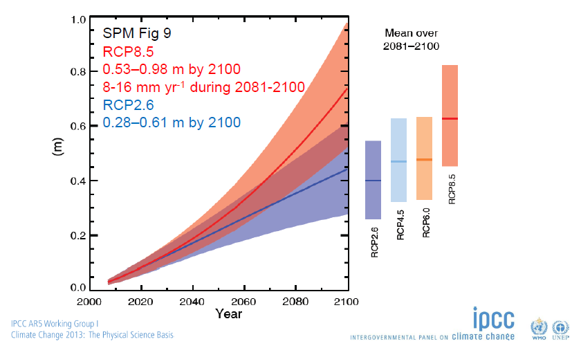
- Christchurch City Council’s interactive map allows you to enter a street address and determine the level of risk and possible time frames based on the scenarios in the 2013 IPCC Report (click on Fig. 6). The names of the scenarios: ‘RCP 2.6’ etc. are explained in the tab at the end of this page. When making these calculations please see this footnote as current (2023-2024) research and observations imply that the worst case (SSP8.5 scenarios)
cannot be dismissed.
- The GNS October 2023 post-earthquake Christchurch vertical land movement (VLM) shows the effects of SLR in several (but not
all) locations will be felt as much as 80 years sooner than anticipated in prior studies. - See also this website ‘Response: Retreating from coasts and rivers: who pays?’
Case study: Greenpark Huts
Te Waihora Lake Ellesemere, the hāpua in the Selwyn District between Ashburton and Ōtautahi Christchurch, is a large coastal lagoon subject to the impacts of rising sea levels. Greenpark Huts is a lakeside settlement on land that belongs to Ngāi Tahu and is leased by residents. When the leases expire 30 June 2024 they will not be renewed and residents will be required to remove the built structures before then.
“In a letter to owners, Ngāi Tahu said the limited availability of acceptable quality drinking water, non-compliant wastewater systems and the inevitable impact of sea level rise were behind its decision.“– Stuff, 29 August 2020
This highlights the complexity of impacts from rising sea levels. As sea levels rise so too will groundwater—currently just 20cm below the surface—posing significant environmental problems on multiple levels. For example, some toilets in the Huts are ‘long-drop’ toilets that cannot prevent seepage into the groundwater, with concurrent impacts to the health of the surround environment including mahinga kai.
”The Greenpark Huts sit on a site of immense cultural and mahinga kai significance to Ngāi Tahu.” – Ngāi Tahu general manager te o tūroa Trudy Heath, August 2020
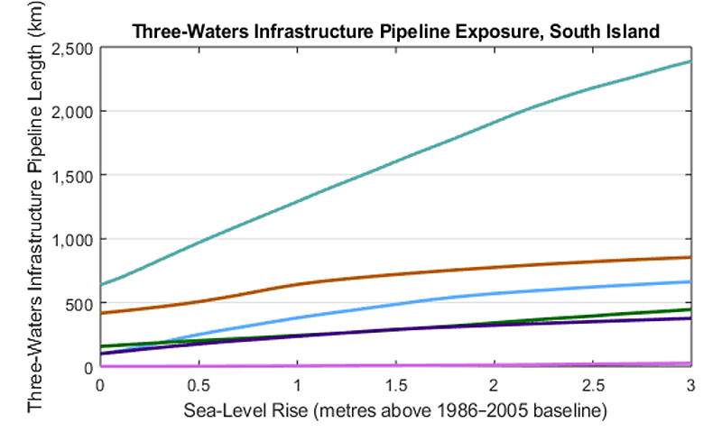
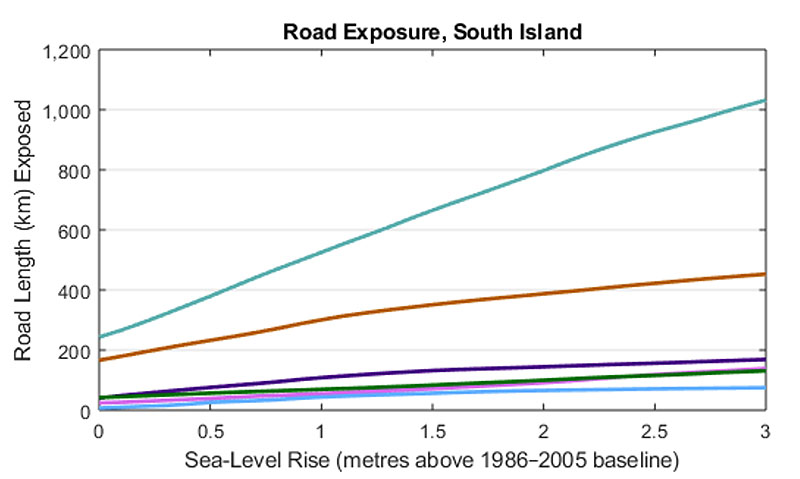
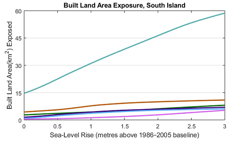
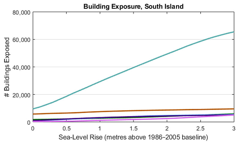
Increasing coastal flooding exposure to Waitaha Canterbury (2022 modelling)
Important Note: does not factor in 2023 figures of vertical land movement
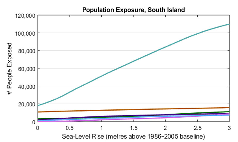
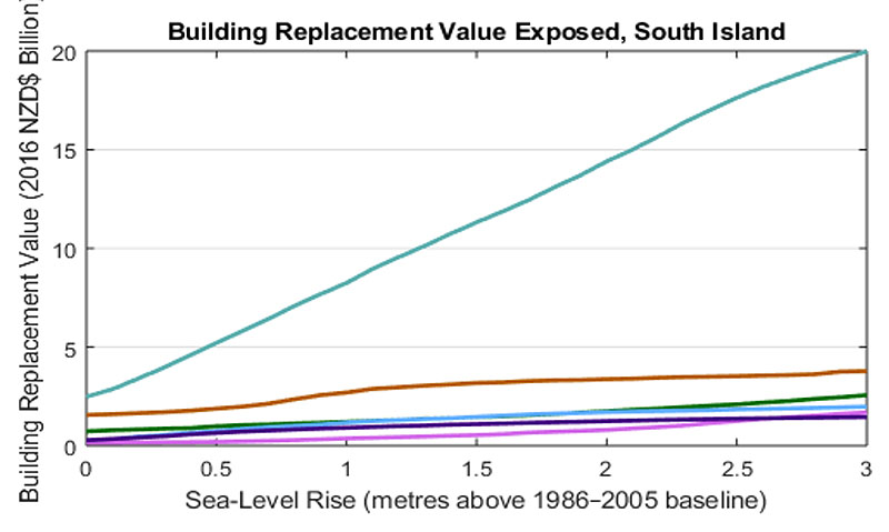
Waitaha Canterbury faces the greatest exposure to the effects of rising sea levels, represented by the teal-coloured uppermost lines in all graphs below (Fig. 6). The other coloured lines are for the remaining Te Waipunamu South Island Districts.
Modelling published in 2022 indicates that wave heights along the east coast will be less than currently experienced. This may reduce the scope and scale of short-term erosion. However, this may be more than offset by more powerful acute events.

